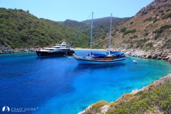
Mersincik Limanı lies 1M SE of the islets; Akçalı and Mersincik on the NW of Datça Peninsula. This is the only natural port in the region, it is open to northerlies, but provides shelter from the prevailing wind. The cove at the entry on starboard, affords all-round shelter. The bottom is sand. Good holding. There is just room for a few yachts for anchorage.
In calm weather, you can anchor in 10-17 m near the hamlet's farmhouses and take a line ashore on the west, though a breeze may cause a swell. The bottom is sand.
Mersincik Limanı is a nice spot with attractice surroundings. Olive trees cover the surrounding hillsides. Mersincik is connected with Knidos-Datça highway (11 km).