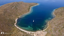
The entrance which overlooks the bay of Edremit, to the north of Maden Island is a thin, long and sheltered bay. It is popularly known as Santral Bay.
At the top you can find a cubic ancient stone structure. It is far from the departure points of the daily tour boats.
Its entrance faces north and is the port to all winds, with the exception of the North wind. The depth is 30 meters at the entrance to the bay which drops evenly until the beach fronts. Although the sea floor structure looks like noodles from above, it is usually dark sand and sparse noodles.
The sea is clean and a little cool. On the shore there is a small old concrete pier and an old structure towards the slope. It is one of the safest and most beautiful bays in the region.


